
Claryville topographic map
Click on the map to display elevation.
About this map
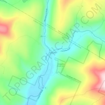
Name: Claryville topographic map, elevation, terrain.
Average elevation: 628 m
Minimum elevation: 477 m
Maximum elevation: 883 m
Other topographic maps
Click on a map to view its topography, its elevation and its terrain.
Grahamsville
United States > New York > Sullivan County > Town of Neversink
Grahamsville is located at latitude 41.848 and longitude -74.548. The elevation is 968 feet. Grahamsville is in the Eastern Time Zone.
Average elevation: 397 m
Grahamsville
United States > New York > Sullivan County > Town of Neversink
Grahamsville is located at latitude 41.848 and longitude -74.548. The elevation is 968 feet. Grahamsville is in the Eastern Time Zone.
Average elevation: 397 m