
Make a donation
Gear up for your next adventure:
As an Amazon Associate, this site earns from qualifying purchases at no extra cost to you.
Ampen topographic map
Click on the map to display elevation.
Make a donation
Gear up for your next adventure:
As an Amazon Associate, this site earns from qualifying purchases at no extra cost to you.
About this map
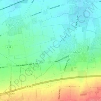
Name: Ampen topographic map, elevation, terrain.
Location: Ampen, Soest, Kreis Soest, Nordrhein-Westfalen, Deutschland (51.54056 8.02433 51.56642 8.06227)
Average elevation: 109 m
Minimum elevation: 86 m
Maximum elevation: 154 m
Make a donation
Gear up for your next adventure:
As an Amazon Associate, this site earns from qualifying purchases at no extra cost to you.
Other topographic maps
Click on a map to view its topography, its elevation and its terrain.
Walburgerhofe
Deutschland > Nordrhein-Westfalen > Kreis Soest > Soest > Walburgerhofe
Average elevation: 94 m
Make a donation
Gear up for your next adventure:
As an Amazon Associate, this site earns from qualifying purchases at no extra cost to you.