
Thank you for supporting this site ❤️
Make a donation
Make a donation
Gear up for your next adventure:
As an Amazon Associate, this site earns from qualifying purchases at no extra cost to you.
Lican topographic map
Click on the map to display elevation.
Thank you for supporting this site ❤️
Make a donation
Make a donation
Gear up for your next adventure:
As an Amazon Associate, this site earns from qualifying purchases at no extra cost to you.
About this map
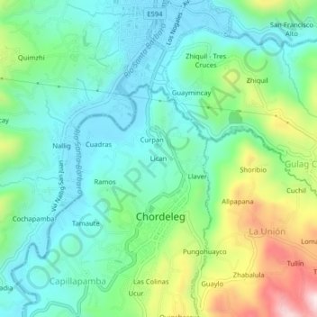
Name: Lican topographic map, elevation, terrain.
Location: Lican, Chordeleg, Azuay, 010350, Ecuador (-2.93496 -78.79640 -2.89496 -78.75640)
Average elevation: 2,368 m
Minimum elevation: 2,227 m
Maximum elevation: 2,730 m
Thank you for supporting this site ❤️
Make a donation
Make a donation
Gear up for your next adventure:
As an Amazon Associate, this site earns from qualifying purchases at no extra cost to you.