Geolocate

Phesama topographic map

Click on the map to display elevation.

About this map

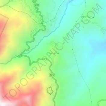
Name: Phesama topographic map, elevation, terrain.

Location: Phesama, Jakhama, Kohima District, Nagaland, 479001, India (25.60993 94.09534 25.64993 94.13534)

Average elevation: 1,534 m

Minimum elevation: 1,161 m

Maximum elevation: 2,280 m

Other topographic maps

Click on a map to view its topography, its elevation and its terrain.

Jakhama

India > Nagaland > Jakhama

Average elevation: 1,907 m

Gear up for your next adventure:

🦶Anti-Blister Balm - Prevents friction and hotspots during long ascents
🥾Mountain Hiking Boots - High-traction boots for rocky terrain
🔋Lithium AA Batteries - Long-lasting power that performs in extreme cold
🧥Ultralight Puffy Jacket - Maximum warmth that packs down to the size of an orange
🔭Outdoor Binoculars - Lightweight binoculars for birdwatching and hiking

As an Amazon Associate, this site earns from qualifying purchases at no extra cost to you.