Geolocate

San Jorge topographic map

Click on the map to display elevation.

About this map

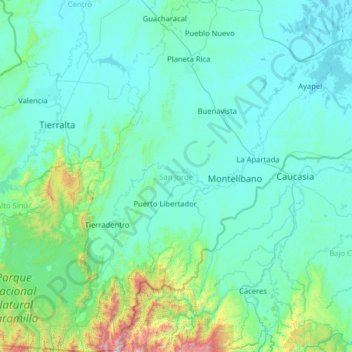
Name: San Jorge topographic map, elevation, terrain.

Location: San Jorge, Córdoba, RAP Caribe, 230003, Colombia (7.35722 -76.05748 8.61628 -74.78514)

Average elevation: 226 m

Minimum elevation: 13 m

Maximum elevation: 2,596 m

Other topographic maps

Click on a map to view its topography, its elevation and its terrain.

Tierra Santa

Colombia > Córdoba > Buenavista

Average elevation: 31 m

La Ye

Colombia > Córdoba > Sahagún

Average elevation: 122 m

Gear up for your next adventure:

🧢Outdoor Visor - Breathable visor for sunny hikes
🛁Quick-Dry Microfiber Towel - Space-saving towel that dries rapidly on the move
🔋Emergency Crank Radio - Weather alerts and power without needing batteries
🛶Kayak Accessories - Essential gear for safe and fun kayaking adventures
🧢Sun Hat - Wide-brim hat for sun protection

As an Amazon Associate, this site earns from qualifying purchases at no extra cost to you.