Geolocate

Geiger Key topographic map

Click on the map to display elevation.

About this map

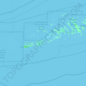
Name: Geiger Key topographic map, elevation, terrain.

Location: Geiger Key, Monroe County, Florida, United States (24.26172 -81.97283 24.90172 -81.33283)

Average elevation: 0 m

Minimum elevation: -2 m

Maximum elevation: 21 m

Other topographic maps

Click on a map to view its topography, its elevation and its terrain.

Key

United States > Florida > Monroe County

Average elevation: 0 m

Key Largo

United States > Florida > Monroe County > Key Largo

Average elevation: 1 m

Layton

United States > Florida > Monroe County

Average elevation: 1 m

Key Largo

United States > Florida > Monroe County

Average elevation: 1 m

Duck Key

United States > Florida > Monroe County > Duck Key

Average elevation: 0 m

Fish Hawk Key

United States > Florida > Monroe County

Average elevation: 0 m

Sawyer Key

United States > Florida > Monroe County

Average elevation: 0 m

Tavernier

United States > Florida > Monroe County > Tavernier

Average elevation: 2 m

Crab Key

United States > Florida > Monroe County

Average elevation: 0 m

Gear up for your next adventure:

🔋Solar Power Bank - Keep your GPS and devices charged during long outdoor trips
🛶Waterproof Dry Bags - Keep electronics and clothes dry during river crossings
🚲Bike Repair Kit - Essential tools for on-trail mechanical issues
🔦LED Headtorch - Bright and durable light for night activities
Lightweight Camping Tent - Portable shelter optimized for Canadian backcountry camping

As an Amazon Associate, this site earns from qualifying purchases at no extra cost to you.