
Make a donation
Gear up for your next adventure:
As an Amazon Associate, this site earns from qualifying purchases at no extra cost to you.
Blaufelden topographic map
Click on the map to display elevation.
Make a donation
Gear up for your next adventure:
As an Amazon Associate, this site earns from qualifying purchases at no extra cost to you.
Blaufelden
Blaufelden liegt auf der Hohenloher Ebene in 320 bis 488 Meter Höhe. Das Gemeindegebiet zieht sich wie ein Gürtel durch den nördlichen Landkreis Schwäbisch Hall, vom Hohenlohekreis bis zur bayerischen Grenze.
Make a donation
Gear up for your next adventure:
As an Amazon Associate, this site earns from qualifying purchases at no extra cost to you.
About this map
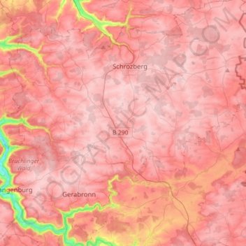
Name: Blaufelden topographic map, elevation, terrain.
Average elevation: 449 m
Minimum elevation: 279 m
Maximum elevation: 502 m
Make a donation
Gear up for your next adventure:
As an Amazon Associate, this site earns from qualifying purchases at no extra cost to you.
Other topographic maps
Click on a map to view its topography, its elevation and its terrain.
Einkorn
Deutschland > Baden-Württemberg > Landkreis Schwäbisch Hall > Schwäbisch Hall
Über eine Holztreppe, deren oberste Stufen innerhalb eines an der Nordostecke des Turms angebauten Scharwachtturms verlaufen, gelangt man zur überdachten Aussichtsplattform, die auf rund 25 m Höhe liegt. Von hier hat man einen weiten Blick über die Haller und Hohenloher Ebene und ins Kochertal hinunter.…
Average elevation: 412 m
Ramsbach
Deutschland > Baden-Württemberg > Landkreis Schwäbisch Hall > Schwäbisch Hall
Average elevation: 391 m
Make a donation
Gear up for your next adventure:
As an Amazon Associate, this site earns from qualifying purchases at no extra cost to you.
Brachbach
Deutschland > Baden-Württemberg > Landkreis Schwäbisch Hall > Übrigshausen
Average elevation: 393 m
Hessental
Deutschland > Baden-Württemberg > Landkreis Schwäbisch Hall > Schwäbisch Hall
Stadtmitte | Nördliche Kernstadt | Kreuzäcker | Südliche Kernstadt | Tullauer Höhe / Hagenbach | Rollhof / Reifenhof | Stadtheide | Heimbachsiedlung / Teurershof | Steinbach | Hessental | Bibersfeld | Gailenkirchen | Gelbingen | Eltershofen | Sulzdorf | Tüngental | Weckrieden
Average elevation: 394 m