
Make a donation
Gear up for your next adventure:
As an Amazon Associate, this site earns from qualifying purchases at no extra cost to you.
Ostheim topographic map
Click on the map to display elevation.
Make a donation
Gear up for your next adventure:
As an Amazon Associate, this site earns from qualifying purchases at no extra cost to you.
Ostheim
Ostheim liegt am Südrand der Wetterau und am Fuß des Ronneburger Hügellandes, einem Ausläufer des Vogelsbergs, auf einer Höhe von 135 Metern über NN, etwa 10 km nördlich von Hanau.
Make a donation
Gear up for your next adventure:
As an Amazon Associate, this site earns from qualifying purchases at no extra cost to you.
About this map
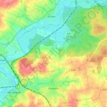
Name: Ostheim topographic map, elevation, terrain.
Location: Ostheim, Nidderau, Main-Kinzig-Kreis, Hessen, Deutschland (50.21543 8.89113 50.26602 8.96278)
Average elevation: 145 m
Minimum elevation: 113 m
Maximum elevation: 187 m
Make a donation
Gear up for your next adventure:
As an Amazon Associate, this site earns from qualifying purchases at no extra cost to you.