Geolocate

Anao topographic map

Click on the map to display elevation.

About this map

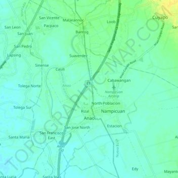
Name: Anao topographic map, elevation, terrain.

Location: Anao, Tarlac, Central Luzon, 2310, Philippines (15.69980 120.59432 15.78580 120.64152)

Average elevation: 20 m

Minimum elevation: 14 m

Maximum elevation: 36 m

Other topographic maps

Click on a map to view its topography, its elevation and its terrain.

Estacion

Philippines > Tarlac > Paniqui

Average elevation: 18 m

Poblacion Center

Philippines > Tarlac > Ramos

Average elevation: 19 m

Salapungan

Philippines > Tarlac > Tarlac City

Average elevation: 42 m

San Vicente

Philippines > Tarlac > Tarlac City

Average elevation: 52 m

Calibungan

Philippines > Tarlac > Calibungan

Average elevation: 24 m

Capas

Philippines > Tarlac

Average elevation: 260 m

Kamatis

Philippines > Tarlac > Capas

Average elevation: 77 m

Gear up for your next adventure:

🧼Travel Hand Sanitizer - Keep hands clean when water is scarce
🔦UV Flashlight - Detect minerals or specific insects in the dark
❄️Traction Ice Cleats - Slip-on spikes for icy trails and winter hiking
🥾Trail Hiking Boots - Supportive boots for rough trails
🧭GPS Outdoor Watch - Smart watch for navigation and fitness tracking in nature

As an Amazon Associate, this site earns from qualifying purchases at no extra cost to you.