Geolocate

Amuyong topographic map

Click on the map to display elevation.

About this map

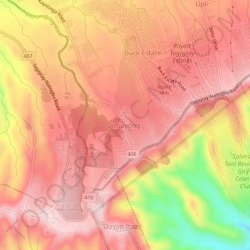
Name: Amuyong topographic map, elevation, terrain.

Location: Amuyong, Alfonso, Cavite, Calabarzon, 4123, Philippines (14.05189 120.83135 14.09189 120.87135)

Average elevation: 529 m

Minimum elevation: 289 m

Maximum elevation: 637 m

Other topographic maps

Click on a map to view its topography, its elevation and its terrain.

Amuyong

Philippines > Cavite > Alfonso

Average elevation: 543 m

Amuyong

Philippines > Cavite > Alfonso

Average elevation: 543 m

Gear up for your next adventure:

🧥Ultralight Puffy Jacket - Maximum warmth that packs down to the size of an orange
Tent Footprint - Protect tent floor and increase durability
👖Convertible Hiking Pants - Zip-off legs to adapt to changing weather conditions
Camping Tent - Weather-resistant tents suitable for 2 to 6 people
🥾Light Hiking Boots - Lightweight and comfortable boots for day hikes

As an Amazon Associate, this site earns from qualifying purchases at no extra cost to you.