Geolocate

Maymangga topographic map

Click on the map to display elevation.

About this map

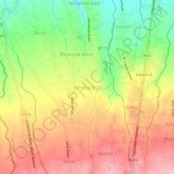
Name: Maymangga topographic map, elevation, terrain.

Location: Maymangga, Amadeo, Cavite, Calabarzon, 4119, Philippines (14.13539 120.92440 14.17539 120.96440)

Average elevation: 484 m

Minimum elevation: 400 m

Maximum elevation: 554 m

Gear up for your next adventure:

🚲MTB Frame Bag - Carry tools and maps directly on your bicycle frame
🧥Thermal Layer - Insulating layer for cold outdoor conditions
🎒Backpack Rain Cover - External shield to keep your entire pack dry
🐕Hiking Dog Pack - Let your canine companion carry their own water and food
🧶550 Survival Paracord - Versatile utility cord for emergency repairs and rigging

As an Amazon Associate, this site earns from qualifying purchases at no extra cost to you.