Geolocate

Túcume topographic map

Click on the map to display elevation.

About this map

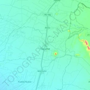
Name: Túcume topographic map, elevation, terrain.

Location: Túcume, Province of Lambayeque, Lambayeque, Peru (-6.53482 -79.94586 -6.47208 -79.79323)

Average elevation: 46 m

Minimum elevation: 24 m

Maximum elevation: 236 m

Gear up for your next adventure:

🧥Waterproof Hiking Jacket - Protect yourself from rain and wind while hiking
Camping Coffee Maker - Brew fresh coffee anywhere on the topographic map
Bushcraft Tarp - Versatile emergency shelter or gear protection
🔋Solar Power Bank - Keep your GPS and devices charged during long outdoor trips
🧢Beanie Hat - Keep your head warm in cold weather

As an Amazon Associate, this site earns from qualifying purchases at no extra cost to you.