Geolocate

Sayang topographic map

Click on the map to display elevation.

About this map

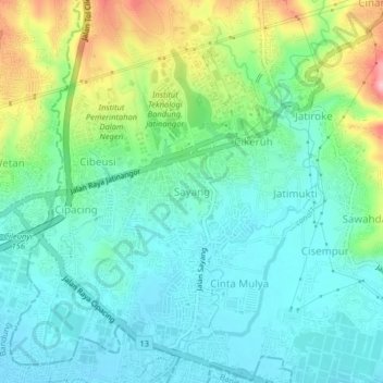
Name: Sayang topographic map, elevation, terrain.

Location: Sayang, Sumedang, West Java, Java, 45363, Indonesia (-6.96687 107.75197 -6.92687 107.79197)

Average elevation: 696 m

Minimum elevation: 665 m

Maximum elevation: 836 m

Other topographic maps

Click on a map to view its topography, its elevation and its terrain.

Situ II ITB

Indonesia > West Java > Sumedang > Jatinangor

Average elevation: 726 m

Gear up for your next adventure:

🧥Packable Rain Jacket - Breathable waterproof layer for unpredictable weather
Camping Essentials - All-in-one gear for a comfortable camping trip
🧢Hiking Sun Hat - Wide-brimmed protection for exposed mountain ridges
🛌Down Sleeping Bag - Superior warmth-to-weight ratio for cold nights
🔭Outdoor Binoculars - Lightweight binoculars for birdwatching and hiking

As an Amazon Associate, this site earns from qualifying purchases at no extra cost to you.