
isla Holy topographic map
Interactive map
Click on the map to display elevation.
About this map
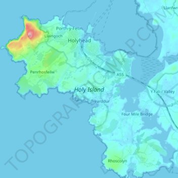
Name: isla Holy topographic map, elevation, terrain.
Location: isla Holy, Isle of Anglesey, Gales, Reino Unido (53.24002 -4.69670 53.33109 -4.55346)
Average elevation: 9 m
Minimum elevation: -1 m
Maximum elevation: 217 m
Other topographic maps
Click on a map to view its topography, its elevation and its terrain.
Pontypool
Reino Unido > Gales > Pontypool
Pontypool, Torfaen, Gales, NP4, Reino Unido
Average elevation: 210 m