Geolocate

Butler topographic map

Click on the map to display elevation.

About this map

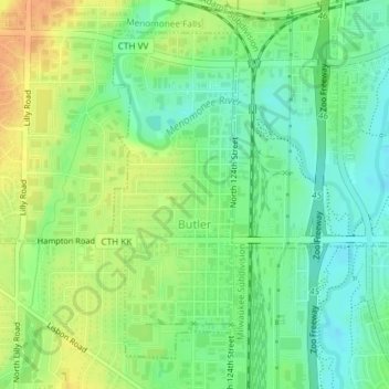
Name: Butler topographic map, elevation, terrain.

Location: Butler, Waukesha County, Wisconsin, 53007, United States (43.09651 -88.07746 43.11930 -88.06551)

Average elevation: 228 m

Minimum elevation: 212 m

Maximum elevation: 248 m

Other topographic maps

Click on a map to view its topography, its elevation and its terrain.

Lapham Hill

United States > Wisconsin > Waukesha County

Average elevation: 314 m

Eagleville

United States > Wisconsin > Waukesha County

Average elevation: 262 m

Eagleville

United States > Wisconsin > Waukesha County

Average elevation: 262 m

Gear up for your next adventure:

🚲MTB Frame Bag - Carry tools and maps directly on your bicycle frame
🧣Evaporative Cooling Towel - Beat the heat during intense summer climbs
🚲Heavy Duty Bike Lock - Secure your bike at the trailhead or during stops
🔦UV Flashlight - Detect minerals or specific insects in the dark
🦌Outdoor Trail Camera - Monitor wildlife activity near your favorite spots

As an Amazon Associate, this site earns from qualifying purchases at no extra cost to you.