Geolocate

Keechi topographic map

Click on the map to display elevation.

About this map

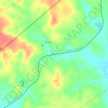
Name: Keechi topographic map, elevation, terrain.

Location: Keechi, Leon County, Texas, United States (31.49684 -95.97330 31.53684 -95.93330)

Average elevation: 102 m

Minimum elevation: 74 m

Maximum elevation: 136 m

Other topographic maps

Click on a map to view its topography, its elevation and its terrain.

Normangee

United States > Texas > Leon County

Average elevation: 118 m

Centerville

United States > Texas > Leon County

Average elevation: 109 m

Buffalo

United States > Texas > Leon County

Average elevation: 111 m

Marquez

United States > Texas > Leon County

Average elevation: 124 m

Marquez

United States > Texas > Leon County

Average elevation: 124 m

Leona

United States > Texas > Leon County

Average elevation: 104 m

Normangee

United States > Texas > Leon County

Average elevation: 118 m

Normangee

United States > Texas > Leon County

Average elevation: 118 m

Buffalo

United States > Texas > Leon County > Buffalo

Average elevation: 109 m

Gear up for your next adventure:

🔋Emergency Crank Radio - Weather alerts and power without needing batteries
🥾Mountaineering Boots - Supportive boots for climbing and high-altitude hiking
🎒Fully Waterproof Backpack - Total protection for photography gear and electronics
🔨Vehicle Emergency Tool - Safety tool for remote road trips to trailheads
🧴Insect Repellent - Protect yourself from bugs during outdoor adventures

As an Amazon Associate, this site earns from qualifying purchases at no extra cost to you.