Geolocate

Himalaia topographic map

Click on the map to display elevation.

About this map

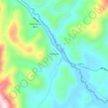
Name: Himalaia topographic map, elevation, terrain.

Location: Himalaia, Itajuru, Jequié, Região Geográfica Imediata de Jequié, Região Geográfica Intermediária de Vitória da Conquista, Bahia, Região Nordeste, Brasil (-14.02222 -39.94971 -13.98222 -39.90971)

Average elevation: 284 m

Minimum elevation: 156 m

Maximum elevation: 631 m

Other topographic maps

Click on a map to view its topography, its elevation and its terrain.

Monte Branco

Brasil > Bahia > Jequié

Average elevation: 549 m

Monte Branco

Brasil > Bahia > Jequié

Average elevation: 549 m

Gear up for your next adventure:

🧶550 Survival Paracord - Versatile utility cord for emergency repairs and rigging
🪑Insulated Seat Pad - Protect your seat from cold rocks and wet logs
🧤Rechargeable Heated Gloves - Extreme warmth for Canadian winter expeditions
Backpacking Tent - Lightweight tent for long-distance hiking trips
🛰️Satellite Messenger - Emergency communication for areas with no cell service

As an Amazon Associate, this site earns from qualifying purchases at no extra cost to you.