
Make a donation
Gear up for your next adventure:
As an Amazon Associate, this site earns from qualifying purchases at no extra cost to you.
Tatamy topographic map
Click on the map to display elevation.
Make a donation
Gear up for your next adventure:
As an Amazon Associate, this site earns from qualifying purchases at no extra cost to you.
About this map
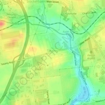
Name: Tatamy topographic map, elevation, terrain.
Average elevation: 114 m
Minimum elevation: 90 m
Maximum elevation: 138 m
Make a donation
Gear up for your next adventure:
As an Amazon Associate, this site earns from qualifying purchases at no extra cost to you.
Other topographic maps
Click on a map to view its topography, its elevation and its terrain.
Weiders Crossing
United States > Pennsylvania > Northampton County > Lehigh Township
Average elevation: 218 m
Pennsville
United States > Pennsylvania > Northampton County > Lehigh Township
Average elevation: 191 m
Raubsville
United States > Pennsylvania > Northampton County > Williams Township
Average elevation: 102 m
Make a donation
Gear up for your next adventure:
As an Amazon Associate, this site earns from qualifying purchases at no extra cost to you.
Slateford
United States > Pennsylvania > Northampton County > Upper Mount Bethel Township
Average elevation: 192 m
Kesslersville
United States > Pennsylvania > Northampton County > Plainfield Township
Average elevation: 177 m
Make a donation
Gear up for your next adventure:
As an Amazon Associate, this site earns from qualifying purchases at no extra cost to you.
Stouts
United States > Pennsylvania > Northampton County > Williams Township > Stouts
Average elevation: 165 m
Green Pond
United States > Pennsylvania > Northampton County > Bethlehem Township
Average elevation: 124 m
Browntown
United States > Pennsylvania > Northampton County > Glendon > Browntown
Average elevation: 114 m
Make a donation
Gear up for your next adventure:
As an Amazon Associate, this site earns from qualifying purchases at no extra cost to you.
Butztown
United States > Pennsylvania > Northampton County > Bethlehem Township
Average elevation: 110 m