Geolocate

Llombera topographic map

Click on the map to display elevation.

About this map

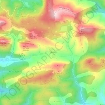
Name: Llombera topographic map, elevation, terrain.

Location: Llombera, La Pola de Gordón, León, Castilla y León, España (42.82321 -5.61204 42.86321 -5.57204)

Average elevation: 1,279 m

Minimum elevation: 1,083 m

Maximum elevation: 1,487 m

Gear up for your next adventure:

🎒Fully Waterproof Backpack - Total protection for photography gear and electronics
🧰Survival Kit - Essential gear for emergencies in the wilderness
🔋Lithium AA Batteries - Long-lasting power that performs in extreme cold
🥾Hiking Boots - Sturdy boots providing ankle support and traction on rugged trails
🔦UV Flashlight - Detect minerals or specific insects in the dark

As an Amazon Associate, this site earns from qualifying purchases at no extra cost to you.