
Île du Canal topographic map
Interactive map
Click on the map to display elevation.
About this map
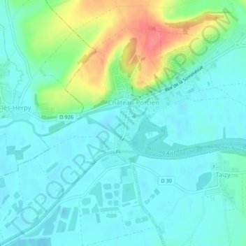
Name: Île du Canal topographic map, elevation, terrain.
Average elevation: 80 m
Minimum elevation: 63 m
Maximum elevation: 133 m
Other topographic maps
Click on a map to view its topography, its elevation and its terrain.
Vieux Marche
France > Grand Est > Ardennes > Château-Porcien
Vieux Marche, Château-Porcien, Rethel, Ardennes, Grand Est, France métropolitaine, 08360, France
Average elevation: 89 m