
Thank you for supporting this site ❤️
Make a donation
Make a donation
Gear up for your next adventure:
As an Amazon Associate, this site earns from qualifying purchases at no extra cost to you.
Klam topographic map
Click on the map to display elevation.
Thank you for supporting this site ❤️
Make a donation
Make a donation
Gear up for your next adventure:
As an Amazon Associate, this site earns from qualifying purchases at no extra cost to you.
Klam
Die komplette Liste der Statistik Austria ist in: Topographische Siedlungskennzeichnung nach STAT
Thank you for supporting this site ❤️
Make a donation
Make a donation
Gear up for your next adventure:
As an Amazon Associate, this site earns from qualifying purchases at no extra cost to you.
About this map
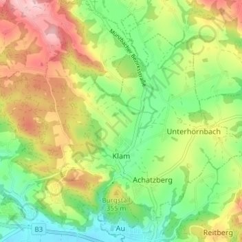
Name: Klam topographic map, elevation, terrain.
Location: Klam, Bezirk Perg, 4352, Österreich (48.21274 14.75724 48.24879 14.81820)
Average elevation: 317 m
Minimum elevation: 232 m
Maximum elevation: 430 m
Thank you for supporting this site ❤️
Make a donation
Make a donation
Gear up for your next adventure:
As an Amazon Associate, this site earns from qualifying purchases at no extra cost to you.