Geolocate

Tagumpay topographic map

Click on the map to display elevation.

About this map

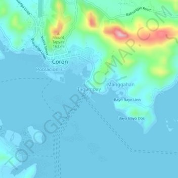
Name: Tagumpay topographic map, elevation, terrain.

Location: Tagumpay, Coron, Palawan, Mimaropa, 5316, Philippines (11.97236 120.19185 12.01236 120.23185)

Average elevation: 30 m

Minimum elevation: -2 m

Maximum elevation: 237 m

Other topographic maps

Click on a map to view its topography, its elevation and its terrain.

Apo Island

Philippines > Palawan > Coron

Average elevation: 22 m

Coron Island

Philippines > Palawan > Coron

Average elevation: 37 m

Bulalacao

Philippines > Palawan > Coron

Average elevation: 3 m

Bulalacao

Philippines > Palawan > Coron

Average elevation: 3 m

Pedrasa Island

Philippines > Palawan > Coron

Average elevation: 18 m

Mayanpayan Island

Philippines > Palawan > Coron

Average elevation: 7 m

Gear up for your next adventure:

🥾Approach Shoes - Shoes designed for climbing approaches and rugged trails
🧴Bear Spray Holster - Quick-access carry for essential Canadian wilderness safety
🥾Lightweight Hiking Boots - Boots for comfort and mobility on long hikes
🥤Collapsible Travel Cup - Saves space and weight in your mess kit
🔦LED Headlamp - Hands-free lighting for early morning starts or late finishes

As an Amazon Associate, this site earns from qualifying purchases at no extra cost to you.