
Make a donation
Gear up for your next adventure:
As an Amazon Associate, this site earns from qualifying purchases at no extra cost to you.
Wildwood Park topographic map
Click on the map to display elevation.
Make a donation
Gear up for your next adventure:
As an Amazon Associate, this site earns from qualifying purchases at no extra cost to you.
Wildwood Park
At Lizard Rock, Teepee Overlook, and similar higher elevation areas, there are panoramic views of the Conejo Valley.
Make a donation
Gear up for your next adventure:
As an Amazon Associate, this site earns from qualifying purchases at no extra cost to you.
About this map
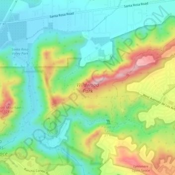
Name: Wildwood Park topographic map, elevation, terrain.
Average elevation: 161 m
Minimum elevation: 69 m
Maximum elevation: 330 m
Make a donation
Gear up for your next adventure:
As an Amazon Associate, this site earns from qualifying purchases at no extra cost to you.
Other topographic maps
Click on a map to view its topography, its elevation and its terrain.
Newbury Park
United States > California > Ventura County > Thousand Oaks > Newbury Park
Newbury Park can be described as a town, community, or section mostly within the Thousand Oaks city limits in addition to rural areas west of Thousand Oaks. Newbury Park is bordered by Lynn Road in the east and the Conejo Grade on the west. It borders the Santa Monica Mountains in the south, while Hill Canyon…
Average elevation: 262 m
Greenwich Village
United States > California > Ventura County > Thousand Oaks > Greenwich Village
Average elevation: 275 m