
Mount Isa topographic map
Interactive map
Click on the map to display elevation.
About this map
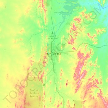
Name: Mount Isa topographic map, elevation, terrain.
Location: Mount Isa, Mount Isa City, Queensland, 4825, Australia (-20.88899 139.33315 -20.56899 139.65315)
Average elevation: 391 m
Minimum elevation: 293 m
Maximum elevation: 564 m
Other topographic maps
Click on a map to view its topography, its elevation and its terrain.
Mica Creek
Australia > Queensland > Mount Isa
Mica Creek, Mount Isa, Mount Isa City, Queensland, 4825, Australia
Average elevation: 403 m