
Make a donation
Gear up for your next adventure:
As an Amazon Associate, this site earns from qualifying purchases at no extra cost to you.
Niederwennerscheid topographic map
Click on the map to display elevation.
Make a donation
Gear up for your next adventure:
As an Amazon Associate, this site earns from qualifying purchases at no extra cost to you.
Niederwennerscheid
Niederwennerscheid liegt im Bergischen Land auf der Nord-Süd-Achse genau zwischen den Hauptorten von Neunkirchen-Seelscheid: Neunkirchen (Süden) und Seelscheid (Norden). Es befindet sich im Naturpark Bergisches Land auf dem Höhenzug Wennerscheid, der von den Läufen des Wahnbachs im Nordwesten und Wendbachs im Süden begrenzt wird. Der nordöstliche Nachbarort ist Oberwennerscheid.
Make a donation
Gear up for your next adventure:
As an Amazon Associate, this site earns from qualifying purchases at no extra cost to you.
About this map
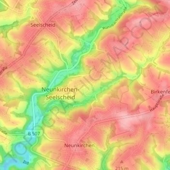
Name: Niederwennerscheid topographic map, elevation, terrain.
Average elevation: 192 m
Minimum elevation: 116 m
Maximum elevation: 236 m
Make a donation
Gear up for your next adventure:
As an Amazon Associate, this site earns from qualifying purchases at no extra cost to you.
Other topographic maps
Click on a map to view its topography, its elevation and its terrain.
Eischeid
Deutschland > Nordrhein-Westfalen > Rhein-Sieg-Kreis > Neunkirchen-Seelscheid
Average elevation: 187 m
Wolperath
Deutschland > Nordrhein-Westfalen > Rhein-Sieg-Kreis > Neunkirchen-Seelscheid
Average elevation: 175 m
Seelscheid
Deutschland > Nordrhein-Westfalen > Rhein-Sieg-Kreis > Neunkirchen-Seelscheid > Hausen
Average elevation: 191 m
53819
Deutschland > Nordrhein-Westfalen > Rhein-Sieg-Kreis > Neunkirchen-Seelscheid > Niederwennerscheid
Average elevation: 190 m
Make a donation
Gear up for your next adventure:
As an Amazon Associate, this site earns from qualifying purchases at no extra cost to you.