Geolocate

Huntly topographic map

Click on the map to display elevation.

About this map
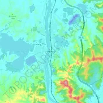
Name: Huntly topographic map, elevation, terrain.

Location: Huntly, Waikato District, Waikato, 3700, New Zealand (-37.59840 175.11883 -37.51840 175.19883)

Average elevation: 41 m

Minimum elevation: -36 m

Maximum elevation: 242 m

Other topographic maps

Click on a map to view its topography, its elevation and its terrain.
Hūnua Ranges

New Zealand > Waikato > Waikato District

Average elevation: 176 m

Lake Kimihia

New Zealand > Waikato > Waikato District

Average elevation: 34 m

Lake Whangape

New Zealand > Waikato > Waikato District

Average elevation: 16 m

Lake Rotokauri

New Zealand > Waikato > Waikato District

Average elevation: 35 m

Lake E

New Zealand > Waikato > Waikato District

Average elevation: 39 m

Gear up for your next adventure:

🦟Insect Repellent - Keep mosquitoes and black flies away in wooded areas
⛺Lightweight Camping Tent - Portable shelter optimized for Canadian backcountry camping
🧴Bear Spray Holster - Quick-access carry for essential Canadian wilderness safety
🥾Mountain Hiking Shoes - Shoes with superior grip for mountainous terrain
🔥Emergency Fire Starter - Reliable ignition source for all weather conditions

As an Amazon Associate, this site earns from qualifying purchases at no extra cost to you.