
Thank you for supporting this site ❤️
Make a donation
Make a donation
Gear up for your next adventure:
As an Amazon Associate, this site earns from qualifying purchases at no extra cost to you.
Crans topographic map
Click on the map to display elevation.
Thank you for supporting this site ❤️
Make a donation
Make a donation
Gear up for your next adventure:
As an Amazon Associate, this site earns from qualifying purchases at no extra cost to you.
About this map
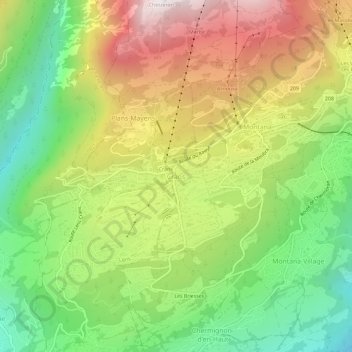
Name: Crans topographic map, elevation, terrain.
Location: Crans, Crans-Montana, Sierre, Vallese, 3960, Svizzera (46.28692 7.44902 46.32692 7.48902)
Average elevation: 1,413 m
Minimum elevation: 854 m
Maximum elevation: 2,113 m
Thank you for supporting this site ❤️
Make a donation
Make a donation
Gear up for your next adventure:
As an Amazon Associate, this site earns from qualifying purchases at no extra cost to you.