
Make a donation
Gear up for your next adventure:
As an Amazon Associate, this site earns from qualifying purchases at no extra cost to you.
Tongatapu topographic map
Click on the map to display elevation.
Make a donation
Gear up for your next adventure:
As an Amazon Associate, this site earns from qualifying purchases at no extra cost to you.
About this map
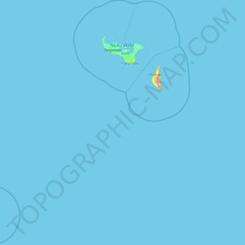
Name: Tongatapu topographic map, elevation, terrain.
Location: Tongatapu, Tonga (-22.54908 -176.43377 -20.81311 -174.76109)
Average elevation: 0 m
Minimum elevation: 0 m
Maximum elevation: 299 m
Make a donation
Gear up for your next adventure:
As an Amazon Associate, this site earns from qualifying purchases at no extra cost to you.
Other topographic maps
Click on a map to view its topography, its elevation and its terrain.
Make a donation
Gear up for your next adventure:
As an Amazon Associate, this site earns from qualifying purchases at no extra cost to you.
Make a donation
Gear up for your next adventure:
As an Amazon Associate, this site earns from qualifying purchases at no extra cost to you.
Hunga Tonga-Hunga Ha’apai
Before the 2014–15 eruption, which connected them into a single island, the islands were separated by about 1.6 km (0.99 mi) of ocean water. Before the 2022 eruption, the highest point in the former Hunga Tonga reached an elevation of 149 m (489 ft), while Hunga Haʻapai was only 128 m (420 ft) above sea…
Average elevation: 4 m
Make a donation
Gear up for your next adventure:
As an Amazon Associate, this site earns from qualifying purchases at no extra cost to you.