
Make a donation
Gear up for your next adventure:
As an Amazon Associate, this site earns from qualifying purchases at no extra cost to you.
Al-Rifa'i District topographic map
Click on the map to display elevation.
Make a donation
Gear up for your next adventure:
As an Amazon Associate, this site earns from qualifying purchases at no extra cost to you.
About this map
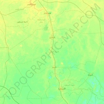
Name: Al-Rifa'i District topographic map, elevation, terrain.
Location: Al-Rifa'i District, Dhi Qar Governorate, Iraq (31.34843 45.72813 31.90926 46.46227)
Average elevation: 9 m
Minimum elevation: 3 m
Maximum elevation: 18 m
Make a donation
Gear up for your next adventure:
As an Amazon Associate, this site earns from qualifying purchases at no extra cost to you.
Other topographic maps
Click on a map to view its topography, its elevation and its terrain.
Nasiriyah
Belgian architect, Jules Tilly, was commissioned to develop a modern urban plan for the city. Tilly introduced a Western-style grid layout, characterised by long, straight, and parallel streets intersecting at right angles, unprecedented in Iraq at the time. This planning approach shaped the city’s…
Average elevation: 5 m
Make a donation
Gear up for your next adventure:
As an Amazon Associate, this site earns from qualifying purchases at no extra cost to you.
Jamaat ash Shaykh
Iraq > Dhi Qar Governorate > Harran as Sajit > Jamaat ash Shaykh
Average elevation: 7 m
Make a donation
Gear up for your next adventure:
As an Amazon Associate, this site earns from qualifying purchases at no extra cost to you.