Geolocate

Pallikkara topographic map

Click on the map to display elevation.

About this map
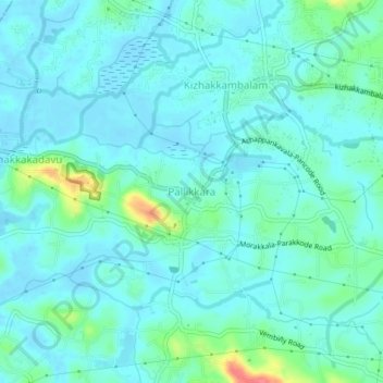
Name: Pallikkara topographic map, elevation, terrain.

Location: Pallikkara, Kunnathunad, Ernakulam, Kerala, 683565, India (10.00564 76.38332 10.04564 76.42332)

Average elevation: 12 m

Minimum elevation: -6 m

Maximum elevation: 65 m

Other topographic maps

Click on a map to view its topography, its elevation and its terrain.

Kadambrayar river

India > Kerala > Kunnathunad > Manakkakadavu

Average elevation: 9 m

Vengola

India > Kerala > Kunnathunad > Perumbavoor

Average elevation: 23 m

Pettamala

India > Kerala > Kunnathunad

Average elevation: 23 m

Umma Chira, Pulluvazhi

India > Kerala > Kunnathunad > Pulluvazhi

Average elevation: 27 m

Rayamangalam

India > Kerala > Kunnathunad > Ambalampady

Average elevation: 31 m

Vadavukode

India > Kerala > Kunnathunad > Meempara

Average elevation: 21 m

Gear up for your next adventure:

🧤Insulated Winter Gloves - Heavy-duty protection for sub-zero Canadian adventures
🛰️Satellite Messenger - Emergency communication for areas with no cell service
🕶️Polarized Sunglasses - Protect your eyes with durable polarized lenses
💧Hydration Pack - Hands-free hydration system for long hikes
🥾Approach Shoes - Shoes designed for climbing approaches and rugged trails

As an Amazon Associate, this site earns from qualifying purchases at no extra cost to you.