Geolocate

Locqueltas topographic map

Click on the map to display elevation.

About this map

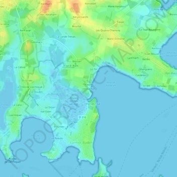
Name: Locqueltas topographic map, elevation, terrain.

Location: Locqueltas, Larmor-Baden, Vannes, Morbihan, Bretagne, France métropolitaine, 56870, France (47.57874 -2.91236 47.61874 -2.87236)

Average elevation: 8 m

Minimum elevation: -2 m

Maximum elevation: 41 m

Other topographic maps

Click on a map to view its topography, its elevation and its terrain.

Île de Berder

France > Bretagne > Morbihan > Larmor-Baden

Longue d'environ 1 200 m du nord au sud et large de 300 m au maximum, l'île culmine dans sa partie centrale à 13 m d'altitude.

Average elevation: 1 m

Gear up for your next adventure:

🧢Sun Hat - Wide-brim hat for sun protection
🥾Lightweight Hiking Shoes - Comfortable shoes for day hikes
🥫Freeze-Dried Meals - Lightweight, high-calorie nutrition for multi-day treks
🧦Crew Hiking Socks - Comfortable socks for long-distance hikes
🥽Outdoor Goggles - Protective eyewear for outdoor activities

As an Amazon Associate, this site earns from qualifying purchases at no extra cost to you.