Geolocate

Manamoc topographic map

Click on the map to display elevation.

About this map

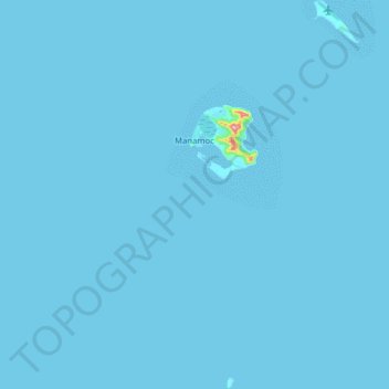
Name: Manamoc topographic map, elevation, terrain.

Location: Manamoc, Cuyo, Palawan, Mimaropa, 5318, Philippines (11.20859 120.67148 11.36284 120.76236)

Average elevation: 1 m

Minimum elevation: 0 m

Maximum elevation: 192 m

Other topographic maps

Click on a map to view its topography, its elevation and its terrain.

Lubid Island

Philippines > Palawan > Cuyo > Lubid

Average elevation: 12 m

Amanpulo

Philippines > Palawan > Cuyo

Average elevation: 0 m

Pandan Island

Philippines > Palawan > Cuyo

Average elevation: 0 m

Gear up for your next adventure:

🥾Durable Hiking Shoes - Long-lasting shoes for frequent hiking
🚲Handlebar Phone Mount - View topographic-map.com live while cycling
🥾Waterproof Hiking Shoes - Durable shoes for wet and rugged trails
Camping Tent - Weather-resistant tents suitable for 2 to 6 people
🧦Outdoor Socks - Durable socks designed for hiking and outdoor sports

As an Amazon Associate, this site earns from qualifying purchases at no extra cost to you.