
Thank you for supporting this site ❤️
Make a donation
Make a donation
Gear up for your next adventure:
As an Amazon Associate, this site earns from qualifying purchases at no extra cost to you.
Bugiallo topographic map
Click on the map to display elevation.
Thank you for supporting this site ❤️
Make a donation
Make a donation
Gear up for your next adventure:
As an Amazon Associate, this site earns from qualifying purchases at no extra cost to you.
About this map
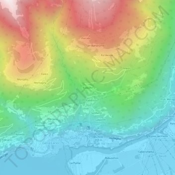
Name: Bugiallo topographic map, elevation, terrain.
Location: Bugiallo, Sorico, Como, Lombardia, 22010, Italia (46.16375 9.36413 46.20375 9.40413)
Average elevation: 691 m
Minimum elevation: 197 m
Maximum elevation: 1,641 m
Thank you for supporting this site ❤️
Make a donation
Make a donation
Gear up for your next adventure:
As an Amazon Associate, this site earns from qualifying purchases at no extra cost to you.