Geolocate

Canza topographic map

Click on the map to display elevation.

About this map

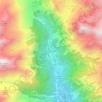
Name: Canza topographic map, elevation, terrain.

Location: Canza, Formazza, Verbano-Cusio-Ossola, Piemonte, 28863, Italia (46.37281 8.39981 46.41281 8.43981)

Average elevation: 1,953 m

Minimum elevation: 1,273 m

Maximum elevation: 2,689 m

Other topographic maps

Click on a map to view its topography, its elevation and its terrain.

Val Formazza

Italia > Piemonte > Verbano-Cusio-Ossola > Formazza

Average elevation: 2,192 m

Gear up for your next adventure:

🧢Hiking Hat - Sun-protective and breathable hats for long treks
🚲Heavy Duty Bike Lock - Secure your bike at the trailhead or during stops
🔋Solar Power Bank - Keep your GPS and devices charged during long outdoor trips
🥤Collapsible Travel Cup - Saves space and weight in your mess kit
🛶Kayak Dry Bag - Waterproof storage for kayaking adventures

As an Amazon Associate, this site earns from qualifying purchases at no extra cost to you.