
The Municipal District of Mullingar — Kinnegad topographic map
Interactive map
Click on the map to display elevation.
About this map
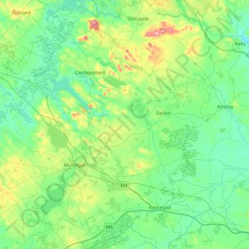
Name: The Municipal District of Mullingar — Kinnegad topographic map, elevation, terrain.
Average elevation: 90 m
Minimum elevation: 47 m
Maximum elevation: 270 m
Other topographic maps
Click on a map to view its topography, its elevation and its terrain.
Mullingar
Mullingar, The Municipal District of Mullingar — Kinnegad, County Westmeath, Comté de Westmeath, Leinster, Irlande
Average elevation: 99 m
Tullin
Tullin, Moydrum ED, The Municipal District of Athlone — Moate, County Westmeath, Comté de Westmeath, Leinster, Irlande
Average elevation: 42 m
Derry
Derry, Castlelost ED, The Municipal District of Mullingar — Kinnegad, County Westmeath, Comté de Westmeath, Leinster, N91 AE6P, Irlande
Average elevation: 84 m
Portloman ED
Portloman ED, The Municipal District of Athlone — Moate, County Westmeath, Comté de Westmeath, Leinster, Irlande
Average elevation: 100 m
Athlone
Irlande > County Westmeath > Athlone
Athlone, The Municipal District of Athlone — Moate, County Westmeath, Leinster, N37 N1F2, Irlande
Average elevation: 44 m