Geolocate

Youbou topographic map

Click on the map to display elevation.

About this map

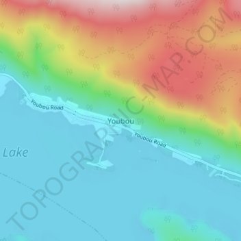
Name: Youbou topographic map, elevation, terrain.

Location: Youbou, Area I (Youbou / Meade Creek), Cowichan Valley Regional District, British Columbia, V0R 3E0, Canada (48.85285 -124.21495 48.89285 -124.17495)

Average elevation: 415 m

Minimum elevation: 158 m

Maximum elevation: 1,043 m

Other topographic maps

Click on a map to view its topography, its elevation and its terrain.

Gear up for your next adventure:

🧢Sun Hat - Wide-brim hat for sun protection
💡Compact LED Flashlight - Powerful and portable flashlight for outdoor use
🔦UV Flashlight - Detect minerals or specific insects in the dark
🧥Fleece Jacket - Warm and lightweight jacket for layering
👟Trail Running Shoes - Agile footwear for fast-paced topographic exploration

As an Amazon Associate, this site earns from qualifying purchases at no extra cost to you.