
Pont-de-Crau topographic map
Interactive map
Click on the map to display elevation.
About this map
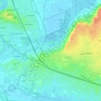
Name: Pont-de-Crau topographic map, elevation, terrain.
Average elevation: 11 m
Minimum elevation: -3 m
Maximum elevation: 42 m
Other topographic maps
Click on a map to view its topography, its elevation and its terrain.
Le Sambuc
Frankrijk > Provence-Alpes-Côte d'Azur > Bouches-du-Rhône > Arles
Le Sambuc, Arles, Bouches-du-Rhône, Provence-Alpes-Côte d'Azur, Metropolitaans Frankrijk, 13104, Frankrijk
Average elevation: 2 m