Geolocate

Metoubes topographic map

Click on the map to display elevation.

About this map

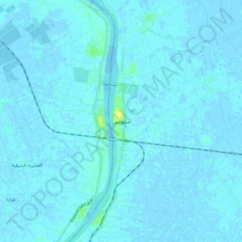
Name: Metoubes topographic map, elevation, terrain.

Location: Metoubes, Kafr El Sheikh, 33625, Egypt (31.25331 30.48327 31.33331 30.56327)

Average elevation: 1 m

Minimum elevation: -3 m

Maximum elevation: 16 m

Other topographic maps

Click on a map to view its topography, its elevation and its terrain.

Desouk

Egypt > Kafr El Sheikh

Average elevation: 5 m

Fuwah City

Egypt > Kafr El Sheikh

Average elevation: 2 m

Desouk

Egypt > Kafr El Sheikh

Average elevation: 5 m

Gear up for your next adventure:

🧣Merino Neck Gaiter - Protects against wind, sun, and cold at high altitudes
🥾Hiking Shoes - Durable and comfortable shoes for trail hiking
🛏️Sleeping Bag - Warm and compact sleeping bags for outdoor camping
🚲Heavy Duty Bike Lock - Secure your bike at the trailhead or during stops
🧥Thermal Layer - Insulating layer for cold outdoor conditions

As an Amazon Associate, this site earns from qualifying purchases at no extra cost to you.