
Make a donation
Gear up for your next adventure:
As an Amazon Associate, this site earns from qualifying purchases at no extra cost to you.
Al Bahah topographic map
Click on the map to display elevation.
Make a donation
Gear up for your next adventure:
As an Amazon Associate, this site earns from qualifying purchases at no extra cost to you.
About this map
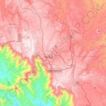
Name: Al Bahah topographic map, elevation, terrain.
Location: Al Bahah, Al-Bahah Province, Saudi Arabia (19.89054 41.37891 20.15454 41.59460)
Average elevation: 1,854 m
Minimum elevation: 598 m
Maximum elevation: 2,563 m
Make a donation
Gear up for your next adventure:
As an Amazon Associate, this site earns from qualifying purchases at no extra cost to you.
Other topographic maps
Click on a map to view its topography, its elevation and its terrain.
Al Bahah
Saudi Arabia > Al-Bahah Province
Al-Baha is the homeland of the Ghamid and Zahran tribes and is divided geographically into three distinct parts: Sarah, which contains the high Hejaz Mountains characterized by temperate weather and rich plant cover due to relatively high annual rainfall, the Tihamah which is the lowland coastal area to the…
Average elevation: 1,744 m
Make a donation
Gear up for your next adventure:
As an Amazon Associate, this site earns from qualifying purchases at no extra cost to you.