Geolocate

Palmarola topographic map

Click on the map to display elevation.

About this map

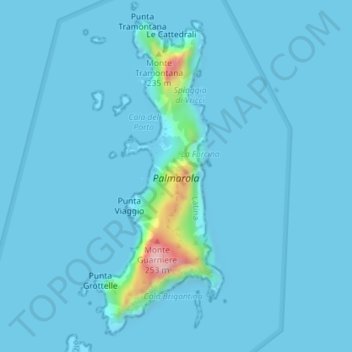
Name: Palmarola topographic map, elevation, terrain.

Location: Palmarola, Ponza, Latina, Lazio, Italy (40.92522 12.84981 40.94961 12.86291)

Average elevation: 13 m

Minimum elevation: -2 m

Maximum elevation: 249 m

Other topographic maps

Click on a map to view its topography, its elevation and its terrain.

Pontine Islands

Italy > Lazio > Latina > Ponza

Average elevation: 0 m

Gear up for your next adventure:

🥾Trail Running Boots - Durable shoes designed for trail running
🩹Moleskin Blister Pads - Direct protection for painful foot pressure points
🔦UV Flashlight - Detect minerals or specific insects in the dark
🥘Camping Cookware Set - Compact nesting pots and pans for trail cooking
🦌Outdoor Trail Camera - Monitor wildlife activity near your favorite spots

As an Amazon Associate, this site earns from qualifying purchases at no extra cost to you.