
Make a donation
Gear up for your next adventure:
As an Amazon Associate, this site earns from qualifying purchases at no extra cost to you.
Chemesquemena topographic map
Click on the map to display elevation.
Make a donation
Gear up for your next adventure:
As an Amazon Associate, this site earns from qualifying purchases at no extra cost to you.
About this map
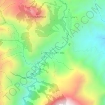
Name: Chemesquemena topographic map, elevation, terrain.
Location: Chemesquemena, Valledupar, Cesar, Colombia (10.69437 -73.41888 10.73437 -73.37888)
Average elevation: 1,365 m
Minimum elevation: 925 m
Maximum elevation: 2,051 m
Make a donation
Gear up for your next adventure:
As an Amazon Associate, this site earns from qualifying purchases at no extra cost to you.
Other topographic maps
Click on a map to view its topography, its elevation and its terrain.
Perímetro Urbano Valledupar
Colombia > Cesar > Valledupar
Su territorio es llano y basculado hacia el suroriente mediante una leve pendiente. La ciudad se encuentra a una altitud que oscila entre los 246 m al norte (Planta de Tratamiento de Agua Potable) y 150 m al Sur (conjunto habitacional Casa de Campo), la altitud media es de 168 m (Plaza Alfonso López). Además…
Average elevation: 163 m