
Make a donation
Gear up for your next adventure:
As an Amazon Associate, this site earns from qualifying purchases at no extra cost to you.
Kadambur topographic map
Click on the map to display elevation.
Make a donation
Gear up for your next adventure:
As an Amazon Associate, this site earns from qualifying purchases at no extra cost to you.
About this map
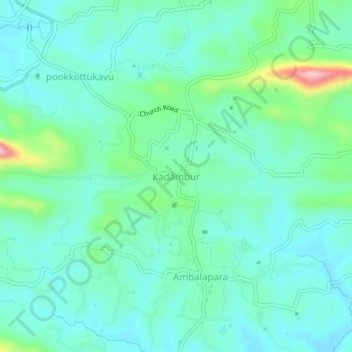
Name: Kadambur topographic map, elevation, terrain.
Location: Kadambur, Ottappalam, Palakkad district, Kerala, 679512, India (10.82418 76.38858 10.86418 76.42858)
Average elevation: 89 m
Minimum elevation: 46 m
Maximum elevation: 247 m
Make a donation
Gear up for your next adventure:
As an Amazon Associate, this site earns from qualifying purchases at no extra cost to you.
Other topographic maps
Click on a map to view its topography, its elevation and its terrain.
Ottappalam
India > Kerala > Ottappalam
Ottapalam is located at 10°46′N 76°23′E / 10.77°N 76.38°E / 10.77; 76.38. It has an average elevation of 54 m (177 ft).
Average elevation: 41 m