Geolocate

Kasing topographic map

Click on the map to display elevation.

Kasing

Kasing liegt am Rande des Naturparks Altmühltal, dem drittgrößten Waldgebiets Deutschlands. Dieses liegt ungefähr 4 km von der Marktgemeinde Kösching entfernt. Die geographische Höhe ist ungefähr 380 m ü. NHN.

Wikipedia (CC-BY-SA 3.0)

About this map

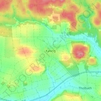
Name: Kasing topographic map, elevation, terrain.

Location: Kasing, Kösching, Landkreis Eichstätt, Bayern, 85092, Deutschland (48.81399 11.52846 48.85399 11.56846)

Average elevation: 414 m

Minimum elevation: 378 m

Maximum elevation: 465 m

Gear up for your next adventure:

🧥Insulated Jacket - Keep warm in cold outdoor conditions
🥾All-Terrain Hiking Boots - Versatile boots for varied hiking conditions
💧Collapsible Water Bottle - Space-saving water bottle for outdoor activities
🌡️Emergency Mylar Blankets - Compact thermal protection for unexpected nights outdoors
🧢Sun Protection Cap - Breathable cap to protect from sun exposure

As an Amazon Associate, this site earns from qualifying purchases at no extra cost to you.