
Make a donation
Gear up for your next adventure:
As an Amazon Associate, this site earns from qualifying purchases at no extra cost to you.
La Suiza topographic map
Click on the map to display elevation.
Make a donation
Gear up for your next adventure:
As an Amazon Associate, this site earns from qualifying purchases at no extra cost to you.
About this map
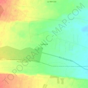
Name: La Suiza topographic map, elevation, terrain.
Location: La Suiza, Villavicencio, Capital, Meta, Colombia (4.01650 -73.71831 4.05650 -73.67831)
Average elevation: 466 m
Minimum elevation: 441 m
Maximum elevation: 495 m
Make a donation
Gear up for your next adventure:
As an Amazon Associate, this site earns from qualifying purchases at no extra cost to you.
Other topographic maps
Click on a map to view its topography, its elevation and its terrain.
Villavicencio
Colombia > Meta > Villavicencio
Topográficamente se distinguen dos regiones: una montañosa ubicada al occidente y noroccidente, formada por el costado de la Cordillera Oriental; la otra, una planicie inclinada ligeramente hacia el oriente y el nororiente, corresponde al piedemonte de la cordillera, bordeada al norte por el río Guatiquía.…
Average elevation: 451 m