
Noailleux topographic map
Interactive map
Click on the map to display elevation.
About this map
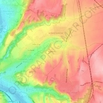
Name: Noailleux topographic map, elevation, terrain.
Average elevation: 251 m
Minimum elevation: 166 m
Maximum elevation: 306 m
Other topographic maps
Click on a map to view its topography, its elevation and its terrain.
Le Domaine de Castellane
France > Auvergne-Rhône-Alpes > Métropole de Lyon > Cailloux-sur-Fontaines > Le Domaine de Castellane
Le Domaine de Castellane, Cailloux-sur-Fontaines, Lyon, Métropole de Lyon, Circonscription départementale du Rhône, Auvergne-Rhône-Alpes, France métropolitaine, 69270, France
Average elevation: 270 m