
Make a donation
Gear up for your next adventure:
As an Amazon Associate, this site earns from qualifying purchases at no extra cost to you.
Victoriaville topographic map
Click on the map to display elevation.
Make a donation
Gear up for your next adventure:
As an Amazon Associate, this site earns from qualifying purchases at no extra cost to you.
Victoriaville
Victoriaville est surplombé par le mont Arthabaska, une colline de 305 mètres. Cependant, le relief de Victoriaville est majoritairement plat, son altitude moyenne variant surtout entre 120 et 150 mètres. La ville est arrosée par deux rivières de taille similaire : la rivière Nicolet et la rivière Bulstrode. Cette dernière alimente le réservoir Beaudet, principal plan d'eau de la ville. On y retrouve également la rivière Gosselin, dans le secteur Arthabaska.
Make a donation
Gear up for your next adventure:
As an Amazon Associate, this site earns from qualifying purchases at no extra cost to you.
About this map
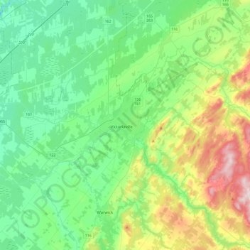
Name: Victoriaville topographic map, elevation, terrain.
Average elevation: 172 m
Minimum elevation: 44 m
Maximum elevation: 534 m
Make a donation
Gear up for your next adventure:
As an Amazon Associate, this site earns from qualifying purchases at no extra cost to you.