
Caldwell topographic map
Click on the map to display elevation.
About this map
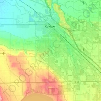
Name: Caldwell topographic map, elevation, terrain.
Location: Caldwell, Canyon County, Idaho, United States (43.58259 -116.72332 43.69779 -116.58340)
Average elevation: 742 m
Minimum elevation: 705 m
Maximum elevation: 803 m
Other topographic maps
Click on a map to view its topography, its elevation and its terrain.
Celebration Park
United States > Idaho > Canyon County
It features camping, restrooms, drinking water, picnicking, guided tours, and interpretive programs as well as fishing and access to hiking trails and the Snake River with a small day use fee. The elevation of the river at the park is approximately 2,250 feet (690 m) above sea level.
Average elevation: 752 m