
Balqaş topographic map
Interactive map
Click on the map to display elevation.
About this map
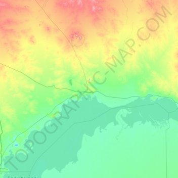
Name: Balqaş topographic map, elevation, terrain.
Location: Balqaş, Karaganda Region, Kazakhstan (46.53834 74.76608 47.24716 77.55557)
Average elevation: 446 m
Minimum elevation: 324 m
Maximum elevation: 1,082 m
Balkhash was founded in 1937 as an industrial city centred on the mining and smelting of copper, and presently copper is still exploited there. The city lies approximately 500 km west of the Chinese border on the north side of the lake at an altitude of 440 m.
Other topographic maps
Click on a map to view its topography, its elevation and its terrain.
Karaganda
Karaganda, Karaganda Region, Kazakhstan
Average elevation: 542 m
Saran, Kazakhstan
Kazakhstan > Karaganda Region > Saran, Kazakhstan
Saran, Kazakhstan, Karaganda Region, Kazakhstan
Average elevation: 502 m
Karaganda
Kazakhstan > Karaganda Region > Караганда Г.А. > Karaganda
Karaganda, Караганда Г.А., Karaganda Region, 100017, Kazakhstan
Average elevation: 539 m
Karkaraly District
Karkaraly District, Karaganda Region, Kazakhstan
Average elevation: 723 m
Karkaraly
Kazakhstan > Karaganda Region > Karkaraly
Karkaraly, Karkaraly District, Karaganda Region, Kazakhstan
Average elevation: 875 m