
Steuben topographic map
Click on the map to display elevation.
About this map
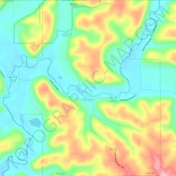
Name: Steuben topographic map, elevation, terrain.
Location: Steuben, Crawford County, Wisconsin, United States (43.16225 -90.88742 43.20546 -90.83444)
Average elevation: 254 m
Minimum elevation: 195 m
Maximum elevation: 352 m
Other topographic maps
Click on a map to view its topography, its elevation and its terrain.
Rattlesnake Point
United States > Wisconsin > Crawford County > Town of Marietta
Average elevation: 232 m
Rattlesnake Point
United States > Wisconsin > Crawford County > Town of Marietta
Average elevation: 232 m