Geolocate

Pesantren topographic map

Click on the map to display elevation.

About this map

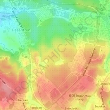
Name: Pesantren topographic map, elevation, terrain.

Location: Pesantren, Mijen, Semarang, Central Java, Indonesia (-7.05055 110.30941 -7.01891 110.33622)

Average elevation: 203 m

Minimum elevation: 150 m

Maximum elevation: 249 m

Other topographic maps

Click on a map to view its topography, its elevation and its terrain.

Kramas

Indonesia > Central Java > Semarang

Average elevation: 170 m

Ngaliyan

Indonesia > Central Java > Semarang

Average elevation: 125 m

Gajahmungkur

Indonesia > Central Java > Semarang

Average elevation: 64 m

Tembalang

Indonesia > Central Java > Semarang > Bulusan

Average elevation: 194 m

Ampelgading

Indonesia > Central Java > Semarang

Average elevation: 196 m

Tikung

Indonesia > Central Java > Semarang

Average elevation: 22 m

Candisari

Indonesia > Central Java > Semarang

Average elevation: 126 m

Tambakaji

Indonesia > Central Java > Semarang

Average elevation: 60 m

Gunungpati

Indonesia > Central Java > Semarang

Average elevation: 303 m

Gear up for your next adventure:

🗺️Topographic Maps - Detailed maps to explore trails, mountains, and wilderness areas
🌬️Windproof Camp Stove - Efficient cooking even on exposed mountain peaks
💡Portable Camping Lamp - Rechargeable lamp for campsite lighting
🥫Freeze-Dried Meals - Lightweight, high-calorie nutrition for multi-day treks
🧊Insulated Water Bottle - Keeps drinks cold in summer and prevents freezing in winter

As an Amazon Associate, this site earns from qualifying purchases at no extra cost to you.